he first castle in Kowalewo was probably built by Teutonic Knights shortly after receiving this land from missionary bishop Christian (d. 1245), which took place in 1231. In 1269, this presumed timber-soil stronghold stopped the siege of Prussian tribe of Barts, but the archaic construction based on fragile building materials was not able to guarantee the safety of their defenders in the future. The Order found out about this only three years later, when a pagan tribe of Jaćwęgowie invaded and then burnt down the Teutonic colony. Shortly after these events, a commandery was established in Kowalewo and the construction of a brick castle began. In 1330, Kowalewo repulsed an invasion of Polish, Hungarian and Russian armed forces led by Władysław Łokietek. The castle, defended by commander Herman von Oppen, was severely damaged then, but was not conquered due to the lack of heavy siege equipment.
A PLATE WITH AN APPROXIMATE DATE OF CASTLE ERECTION PLACED ON THE PILLAR OF THE DANSKER
I
n July 1410, in the battle of Grunwald, commander Michael von Viltz was killed, and soon afterwards the Polish units under the command of Mikołaj Pilewski and Jan from Pułków occupied the town. Kowalewo was then leased to
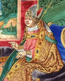
Mikołaj Trąba (d. 1422), one of the closest and most trusted royal courtiers. The Polish occupation of the town, which lasted several months, was ended by an offensive of Teutonic military troops supported by knights of Livonia under the command of Landmarshal Bern Hevelmann, while the first Peace of Toruń sanctioned the ownership of these lands, that remained Teutonic. At the beginning of 1454 citizens of Kowalewo joined an uprising against the Order and took over the stronghold without any fight. Three years after these events it was given to Oldřich Červonka (d. 1465), whose name opens a long list of the starosts of Kowalewo, who were in office at the castle from 1457 to 1772. On the basis of the peace agreement signed in Toruń in 1466, the town became the part of Poland.
REMNANTS OF CASTLE FOUNDATIONS
U
nder Polish rule the castle lost much of its former glory, and at the beginning of the 17th century its condition was so bad that the local parliament in Grudziądz demanded its repair. The building was severely damaged during the Swedish occupation in 1629 when it was taken over and plundered by units commanded by Gen. Wrangl. The difficult situation of the starost's seat after the end of the wars with Sweden is shown by the inspection of the castle carried out in 1662, in which we read: There's only one bastion in the courtyard where there's a room where the governor stands. [...] The stables are all broken. The tower [...] collapsed and ruined. In 1685 Sejm decided to rebuild the castle, but due to lack of funds the investment was abandoned. It was used until 1772, when it was finally left behind due to its condition. Since then, successive demolition of Gothic stronghold began, and the brick regained as a result was used to build an evangelical church with a parish house. In 1911 a water tower was erected in the area of a former upper castle.
VIEW OF THE RUINS FROM THE TIMES WHEN STRAŻACKA STREET WAS YET A DIRT ROAD (1918)
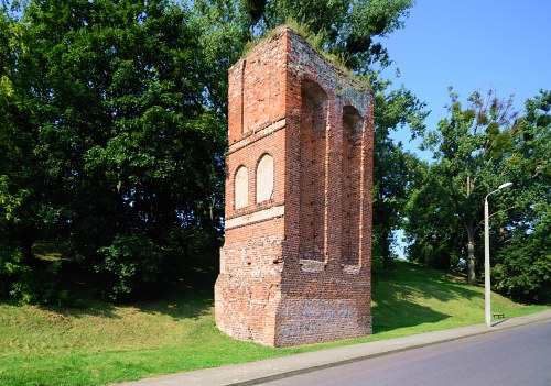
CASTLE HILL WITH AN XXTH-CENTURY WATER TOWER, POSTCARD FROM AROUND 1915
he castle was erected on high, southern shore of a vast lake (1), in the vicinity of narrow isthmus, which led the trade route towards Brodnica. It consisted of a regular quadrilateral brick conventual building and three baileys, surrounded by walls and integrated with the town. With a high degree of probability we can determine that the convent house (2) was a building made of brick on stone foundation with a length of 45 meters each side, with an entrance (3) on the south-west. Presumably, in its southern wing there was a chapel (5) (on the eastern side) and a refectory (6) (on the western side), and in the western wing (7) there were dormitories with commander's apartment.
PLAN OF UPPER CASTLE RUINS ACCORDING TO B. WASIK: 3. ENTRANCE GATE IN THE SOUTH WING, 4. GATE NECK, 5. CHAPEL,
6. REFECTORY, 7. WEST WING, 8. COURTYARD, 9. PILLAR OF THE TOILET TOWER (PRESERVED), 10. INTER-WALL, 11. EAST WALL (PRESERVED)
O
ther wings probably served as kitchen, warehouses, bakery, etc. All the buildings of the upper castle were cellared except small fragments of the southern and eastern parts, and their width was about 13 meters. Communication between rooms was provided by porches leading around a square wooden courtyard (8). The castle did not have a main tower, and in all probability it also had no corner turrets.
CASTLE AND TOWN PLAN BY C. STEINBRECHT: 1. LAKE, 2. UPPER CASTLE 3. ENTRANCE TO THE CASTLE FROM THE BAILEY, 9. TOILET TOWER,
12. SOUTH BAILEY, 13. QUADRILATERAL TOWER, 14. SOUTH WALL TOWER, 15. MIDDLE BAILEY, 16. TOWER, 17. WEST BAILEY,
18. TOWN, 19. CHURCH
A
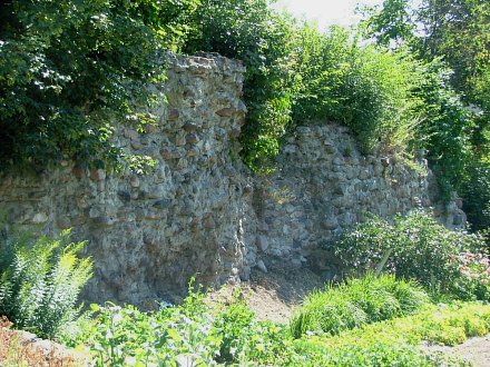
porch, supported by a pillar (9), was led out of the upper castle to the north, and ended with a toilet tower. Richly decorated with blends and friezes, the brick pillar is today the best preserved relic of Teutonic Castle. The conventual part of the stronghold was surrounded by external walls forming an inter-wall (10), which in its eastern section (11) also survived to the present day. Auxiliary functions to the castle were carried out within three baileys located south-west of the convent house. The southernmost outer bailey (12) had a plan similar to rectangle with sides of 118x58 meters - it was fortified by a quadrilateral tower (13) on the west and a tower in the southern side (14). From northeast, it was adjacent to the middle bailey (15) of about 60x70 meters plan, with a tower (16) in the southern wall.
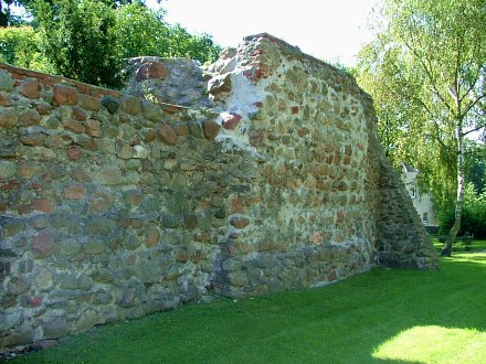
WALLS OF THE SOUTHERN BAILEY
T
he smallest one was the western bailey (17), however, due to poor legibility it is not possible today to clearly define its dimensions and layout. On the northern side, the upper castle was protected by two semi-cylindrical towers. The internal part of the bailey consisted of wooden buildings of economic and military character: malt house, brewery, flour storehouses, bakery, temple workshop, powder magazine and stables.
he pillar of the toilet tower (dansker) has been preserved in good condition to this day, as well as, to a certain extent, parts of
bailey walls. Also
small fragments of southern wall and foundations of the convent house hidden underground have survived. On the castle hill, probably within former courtyard, stands the early 20th-century water tower.
Admission free
ABOVE: THE CASTLE HILL, BELOW: DANSKER PILLAR AND THE XX-CENTURY WATER TOWER
GETTING THERE
K
owalewo Pomorskie is located 30 km northeast of Toruń, by the Toruń-Olsztyn railway route. The railway station is 30 minutes walk away from the castle hill. Relics of the medieval castle are located in the northern part of the town, on Strażacka Street.
A large number of parking places are nearby.
BIBLIOGRAPHY
1. M. Chorowska: Rezydencje średniowieczne na Śląsku, OFPWW 2003
2. I. T. Kaczyńscy: Zamki w Polsce południowej, Muza SA 1999
3. L. Kajzer, J. Salm, S. Kołodziejski: Leksykon zamków w Polsce, Arkady 2001
4. R. Łuczyński: Zamki, dwory i pałace w Sudetach, Wspólnota Akademicka 2008
5. M. Perzyński: Dolnośląskie zamki, dwory i pałace, Wrocławski Dom Wydawniczy 2012
6. M. Świeży: Zamki, twierdze, warownie, Foto Art 2002
7. A. Wagner: Murowane budowle obronne w Polsce X-XVIIw., Bellona 2019
CYLINDRICAL TOWER IS A RELIC OF THE OLD TOWN FORTIFICATIONS
Castles nearby: Golub-Dobrzyń - Teutonic castle from the 14th century, 12 km Wąbrzeźno - relics of Chelmno bishops' castle from the 14th century, 17 km
Lipieniek - relics of Teutonic castle from the 14th century, 27 km Złotoria - ruins of the royal castle from the 14th century, 27 km Toruń - ruins of Teutonic castle from the 13th century, 27 km Toruń - ruins of the royal castle Dybów from the 15th century, 28 km Radziki Duże - ruins of a knight's castle from the 14th/15th century, 29 km
Papowo Biskupie - ruins of Teutonic castle from the 14th century, 30 km Radzyń Chełmiński - ruins of Teutonic castle from the 13th century, 30 km Brodnica - ruins of the Teutonic castle from the 14th century, 33 km